Southwest corner of the Temple Mount at sunset
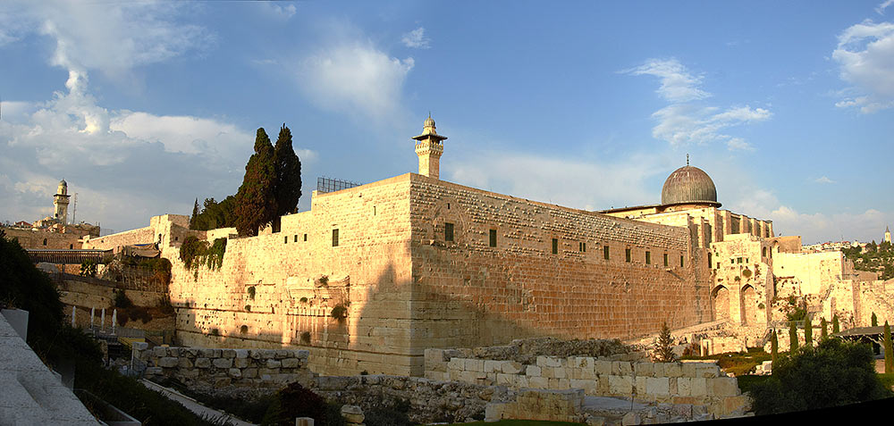
Temple Mount, also known as Har a-Bayt or Har a-Moriya in Hebrew, or al-Haram al-Quds al-Sharif in Arabic. It has absolute height 774 m above sea level. It acquired its current appearance under Herod the Great, who surrounded its perimeter with retaining walls and filled the entire interior space with soil. The height of the walls at the highest point is 45 meters. The total volume of masonry retaining walls is comparable to the volume of the great pyramids of the Giza plateau.
Al-Aqsa dome is visible on the photo on the right, on the left - a ramp to the Maghrib Gate and the Western Wall. In the center al-Gawanima minaret built under the Mamluk sultan Husam ed-Dinom Matshuneh in 1297 is visible.
Land forts and fortress:
Bip Castle Gatchina Ivangorod Izborsk Kexholm Kirillov Monastery Koporye Novgorod Pechorskiy Monastery Peter&Paul Fortress Porkhov Pskov Schlisselburg Staraya Ladoga Tikhvin Vyborg Hameenlinna Hamina Kastelholm Kymenlinna Lappaenranta Raseborg Castle Savonlinna Tavetti Turku Visby Fredrikstadt Fredriksten Hegra Fort Hoytorp Fort Arensburg Narva Tallinn Antipatris Caesarea Jerusalem Latrun Fort Masada
Sea forts and fortresses:
Alexander Fort Ino Fort Krasnaya Gorka Fort Kronstadt: city and Kotlin isl. Kronstadt: North Forts Kronstadt: South Forts Trongsund Hanko Svartholm Sveaborg Marstrand Siaro Fort Vaxholm Oscarsborg
Artillery batteries and individual guns:
Hemso Fort
Fortified areas and defensive lines:
Karelian Fortified Area (KaUR) KrUR Leningrad Mannerheim Line Nevsky Bridgehead VT Line Harparskog Line Mikkeli Salpa Line Gothland
Russian
S e a r c h All news
©2026 Goss.Ru